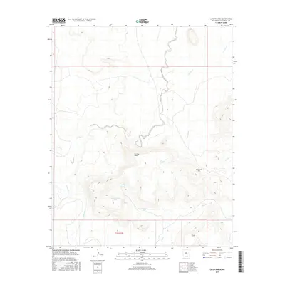
2017 Map of La Cinta Mesa
USGS Topo · Published 2017About this map
The Canadian River cuts through the southwestern corner of this high desert landscape in San Miguel County, a region defined by dramatic flat-topped landforms and seasonal watercourses. La Cinta Mesa dominates the central portion of the sheet, surrounded by a complex network of drainages including La Cinta Creek, Tulosa Cr, and Puertocito Cr. The land use is characterized by livestock management in an arid environment, evidenced by the strategic placement of water sources such as La Cinta Tank, Sunflower Tank, and High Lonesome Tank. Notable topographic landmarks like Chical Mesa and Puertocito Pass indicate the natural corridors used for movement across this dissected terrain. This survey provides a precise look at the 2017 distribution of ranching infrastructure and the intricate contours of the mesas, offering a clear record of the geographic features that have long dictated the patterns of life and travel in this part of New Mexico.
Find a feature on this map
15 named features on this map. Tap any name to fly to it.
Don’t see what you’re looking for? This feature index may not catch every label — zoom into the map to look around manually.
Map Details
Editions of this 2017 La Cinta Mesa Map
This is the sole edition of this map. No revisions or reprints were ever made.
Other maps of this area

1930 · Tucumcari
USGS Topo · 1:125,000

1954 · Santa Fe
USGS Topo · 1:250,000

1954 · Tucumcari
USGS Topo · 1:250,000

1958 · Santa Fe
USGS Topo · 1:250,000

1958 · Tucumcari
USGS Topo · 1:250,000

1967 · Tenaja Mesa
USGS Topo · 1:24,000

1967 · Monument Point
USGS Topo · 1:24,000

1968 · La Cinta Mesa
USGS Topo · 1:24,000

1968 · Carpenter Mesa SW
USGS Topo · 1:24,000

1968 · Carpenter Mesa NW
USGS Topo · 1:24,000