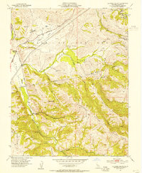
1953 Map of La Costa Valley
USGS Topo · Published 1954About this map
The Valle de San Jose and La Costa Valley are defined by an intricate network of ridgelines and water infrastructure in the early 1950s. Infrastructure developments like the Hetch Hetchy Aqueduct and the Vallecitos Pipe Line cut across the landscape, illustrating the region's vital role in California's water management during this era of post-war expansion. While the high ground is dominated by Maguire Peaks and the steep terrain of Wauhab Ridge and Apperso n Ridge, the lowlands contain pockets of institutional activity including the US Veterans Administration facility and the Arroyo Del Valle Sanatorium.
Find a feature on this map
32 named features on this map. Tap any name to fly to it.
Don’t see what you’re looking for? This feature index may not catch every label — zoom into the map to look around manually.
Map Details
Editions of this 1953 La Costa Valley Map
3 editions found
Other maps of this area

1889 · San Jose
USGS Topo · 1:62,500

1897 · San Jose
USGS Topo · 1:62,500

1897 · Mt. Hamilton
USGS Topo · 1:62,500

1899 · San Jose
USGS Topo · 1:62,500

1906 · Pleasanton
USGS Topo · 1:62,500

1907 · Tesla
USGS Topo · 1:62,500

1941 · Pleasanton
USGS Topo · 1:62,500

1942 · Mt. Hamilton
USGS Topo · 1:62,500

1942 · Altamont
USGS Topo · 1:62,500

1943 · Pleasanton
USGS Topo · 1:62,500