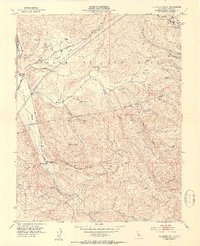
1953 Map of La Costa Valley
USGS Topo · Published 1954About this map
Valle de San Jose and the surrounding heights of Alameda County appear here during the early 1950s, defined by the infrastructure of water and rail transport. The Hetch Hetchy Aqueduct cuts through the terrain, a critical piece of regional utility work that parallels the drainage of La Costa Creek. Near the northern border, the Arroyo Del Valle Sanatorium stands as a distinct institutional landmark near the Arroyo Valle.
Find a feature on this map
29 named features on this map. Tap any name to fly to it.
Don’t see what you’re looking for? This feature index may not catch every label — zoom into the map to look around manually.
Map Details
Editions of this 1953 La Costa Valley Map
3 editions found
Other maps of this area

1889 · San Jose
USGS Topo · 1:62,500

1897 · San Jose
USGS Topo · 1:62,500

1897 · Mt. Hamilton
USGS Topo · 1:62,500

1899 · San Jose
USGS Topo · 1:62,500

1906 · Pleasanton
USGS Topo · 1:62,500

1907 · Tesla
USGS Topo · 1:62,500

1941 · Pleasanton
USGS Topo · 1:62,500

1942 · Mt. Hamilton
USGS Topo · 1:62,500

1942 · Altamont
USGS Topo · 1:62,500

1943 · Pleasanton
USGS Topo · 1:62,500