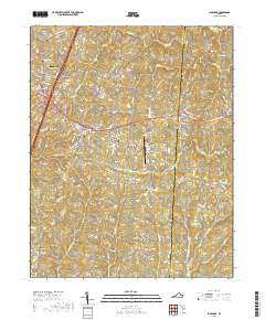
2019 Map of La Crosse
USGS Topo · Published 2019About this map
South Hill and the neighboring town of La Crosse anchor this Southern Virginia landscape, marking a significant intersection of local transport and commerce. The map details the transition from the relatively dense residential streets of South Hill, such as E Atlantic St and Marrow St, to the rural hamlets of Brodnax and Blackridge. This area is characterized by a dense network of watercourses including Great Cr, Miles Cr, and Evans Cr, which have historically dictated the placement of roads and property lines across the Mecklenburg and Brunswick county border.
Find a feature on this map
109 named features on this map. Tap any name to fly to it.
Don’t see what you’re looking for? This feature index may not catch every label — zoom into the map to look around manually.
Map Details
Editions of this 2019 La Crosse Map
This is the sole edition of this map. No revisions or reprints were ever made.
Other maps of this area

1918 · Lawrenceville
USGS Topo · 1:62,500

1919 · White Plains
USGS Topo · 1:48,000

1920 · Lawrenceville
USGS Topo · 1:48,000

1920 · White Plains
USGS Topo · 1:62,500

1921 · Lawrenceville
USGS Topo · 1:62,500

1942 · Lawrenceville
USGS Topo · 1:62,500

1953 · Norfolk
USGS Topo · 1:250,000

1953 · Greensboro
USGS Topo · 1:250,000

1954 · Greensboro
USGS Topo · 1:250,000

1955 · Kenbridge
USGS Topo · 1:62,500