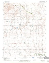
1968 Map of La Crosse NW
USGS Topo · Published 1971About this map
The Smoky Hill River meanders across this rural landscape, cutting through the northern reaches of the Hampton and Fairview townships. The terrain is defined by the prominent Smoky Hill Lookout, which provides a high-ground perspective over the river valley and its associated drainage features like Big Timber Creek. This late-1960s survey illustrates a region where agriculture and resource extraction are the primary economic drivers, evidenced by the numerous oil wells and sandpits scattered throughout the drainage basins.
Find a feature on this map
13 named features on this map. Tap any name to fly to it.
Don’t see what you’re looking for? This feature index may not catch every label — zoom into the map to look around manually.
Map Details
Editions of this 1968 La Crosse NW Map
This is the sole edition of this map. No revisions or reprints were ever made.
Other maps of this area

1893 · Ellis
USGS Topo · 1:125,000

1896 · Hays
USGS Topo · 1:125,000

1955 · Great Bend
USGS Topo · 1:250,000

1957 · Great Bend
USGS Topo · 1:250,000

1958 · Great Bend
USGS Topo · 1:250,000

1961 · Hays South
USGS Topo · 1:24,000

1961 · Antonino
USGS Topo · 1:24,000

1965 · Mc Cracken
USGS Topo · 1:24,000

1966 · La Crosse
USGS Topo · 1:24,000

1966 · Hargrave
USGS Topo · 1:24,000