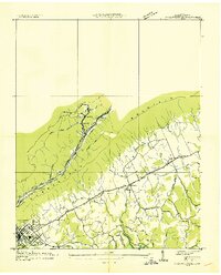
1936 Map of La Follette
USGS Topo · Published 1936About this map
Cumberland Mountain dominates the northern landscape of this 1936 survey, where the Louisville and Nashville Line snakes through the high passes near Peabody and Duff. The topography reveals an industrial mountain economy, evidenced by an Incline near the mountain crest and several transmission lines crossing the ridge. Below the slopes, the southern portion of the map is defined by the newly formed Norris Reservoir, its rising waters meeting the mouths of Cedar Creek and Big Creek.
Find a feature on this map
34 named features on this map. Tap any name to fly to it.
Don’t see what you’re looking for? This feature index may not catch every label — zoom into the map to look around manually.
Map Details
Editions of this 1936 La Follette Map
This is the sole edition of this map. No revisions or reprints were ever made.
Other maps of this area

1886 · Cumberland Gap
USGS Topo · 1:125,000

1888 · Cumberland Gap
USGS Topo · 1:125,000

1890 · Williamsburg
USGS Topo · 1:125,000

1891 · Cumberland Gap
USGS Topo · 1:125,000

1893 · Briceville
USGS Topo · 1:125,000

1894 · Williamsburg
USGS Topo · 1:125,000

1895 · Briceville
USGS Topo · 1:125,000

1896 · Briceville
USGS Topo · 1:125,000

1897 · Maynardville
USGS Topo · 1:125,000

1900 · Maynardville
USGS Topo · 1:125,000