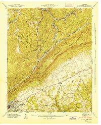
1946 Map of La Follette
USGS Topo · Published 1947About this map
Cumberland Mountain dominates this landscape, forming a massive natural barrier that separates the coal-rich hollows of the north from the broader farming valleys of the south. In the lower reaches, La Follette serves as a primary hub, its street grid revised in 1945 to reflect its postwar growth. The complex topography is defined by narrow gaps like Brushy Mtn Gap and Chambers Gap, which provide essential passage through the ridges. To the southeast, the rising waters of Norris Reservoir reach into the valleys, illustrating the major hydraulic changes managed by the Tennessee Valley Authority.
Find a feature on this map
60 named features on this map. Tap any name to fly to it.
Don’t see what you’re looking for? This feature index may not catch every label — zoom into the map to look around manually.
Map Details
Editions of this 1946 La Follette Map
This is the sole edition of this map. No revisions or reprints were ever made.
Other maps of this area

1886 · Cumberland Gap
USGS Topo · 1:125,000

1888 · Cumberland Gap
USGS Topo · 1:125,000

1890 · Williamsburg
USGS Topo · 1:125,000

1891 · Cumberland Gap
USGS Topo · 1:125,000

1893 · Briceville
USGS Topo · 1:125,000

1894 · Williamsburg
USGS Topo · 1:125,000

1895 · Briceville
USGS Topo · 1:125,000

1896 · Briceville
USGS Topo · 1:125,000

1897 · Maynardville
USGS Topo · 1:125,000

1900 · Maynardville
USGS Topo · 1:125,000