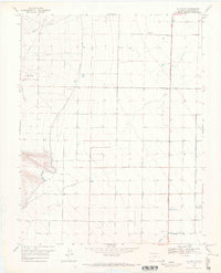
1968 Map of La Garita
USGS Topo · Published 1971About this map
La Garita and the surrounding high desert of Saguache County are defined by a complex irrigation network vital to the San Luis Valley's agricultural history. This 1968 survey illustrates a landscape of precision engineering where the Rio Grande Canal, Farmers Union Canal, and Main North Canal distribute water across an otherwise arid plain. Smaller waterways like Lateral 5 A branch off to serve individual farm plots, contrasting with the natural, winding paths of Carnero Creek and La Garita Creek.
Find a feature on this map
12 named features on this map. Tap any name to fly to it.
Don’t see what you’re looking for? This feature index may not catch every label — zoom into the map to look around manually.
Map Details
Editions of this 1968 La Garita Map
2 editions found
Other maps of this area

1915 · Del Norte
USGS Topo · 1:125,000

1917 · Del Norte
USGS Topo · 1:125,000

1945 · Durango
USGS Topo · 1:250,000

1953 · Durango
USGS Topo · 1:250,000

1954 · Durango
USGS Topo · 1:250,000

1961 · Durango
USGS Topo · 1:250,000

1963 · Durango
USGS Topo · 1:250,000

1964 · Sevenmile Plaza
USGS Topo · 1:24,000

1966 · Durango
USGS Topo · 1:250,000
1966 · Del Norte
USGS Topo · 1:24,000