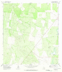
1972 Map of La Gloria SW
USGS Topo · Published 1975About this map
El Negro Ranch and a sparse network of ranching infrastructure define this corner of South Texas during the early 1970s. The landscape is marked by the vital necessity of water in a semi-arid environment, shown through numerous landmarks such as the Borrachito Windmill, Benedito Windmill, and the Charco del Rucio Tank. These named water sources, alongside Sad Ignacio Windmill No 1, reveal the localized cattle-ranching economy that persisted even as industrial interests moved into the area.
Find a feature on this map
16 named features on this map. Tap any name to fly to it.
Don’t see what you’re looking for? This feature index may not catch every label — zoom into the map to look around manually.
Map Details
Editions of this 1972 La Gloria SW Map
2 editions found
Other maps of this area

1938 · El Sauz
USGS Topo · 1:62,500

1938 · Sal Colorada
USGS Topo · 1:62,500

1949 · Mc Allen
USGS Topo · 1:250,000

1954 · McAllen
USGS Topo · 1:250,000

1956 · Garcias
USGS Topo · 1:62,500

1956 · Escobares
USGS Topo · 1:62,500

1957 · Mc Allen
USGS Topo · 1:250,000

1962 · McAllen
USGS Topo · 1:250,000
1965 · Camp Garcia
USGS Topo · 1:24,000
1965 · Sagunada Ranch
USGS Topo · 1:24,000