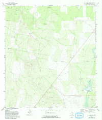
1972 Map of La Gloria SW
USGS Topo · Published 1993About this map
The arid landscape of Starr County, Texas, is defined by the critical infrastructure of water and resource extraction during the early 1970s. This ranching territory relies on scattered water sources such as the Borrachito Windmill, Benedito Windmill, and the Charco del Rucio Tank, which are essential for livestock in this semi-desert environment. El Negro Ranch stands as a primary hub of activity in a region characterized by sparse settlement and wide-open rangeland.
Find a feature on this map
15 named features on this map. Tap any name to fly to it.
Don’t see what you’re looking for? This feature index may not catch every label — zoom into the map to look around manually.
Map Details
Editions of this 1972 La Gloria SW Map
2 editions found
Other maps of this area

1938 · El Sauz
USGS Topo · 1:62,500

1938 · Sal Colorada
USGS Topo · 1:62,500

1949 · Mc Allen
USGS Topo · 1:250,000

1954 · McAllen
USGS Topo · 1:250,000

1956 · Garcias
USGS Topo · 1:62,500

1956 · Escobares
USGS Topo · 1:62,500

1957 · Mc Allen
USGS Topo · 1:250,000

1962 · McAllen
USGS Topo · 1:250,000
1965 · Camp Garcia
USGS Topo · 1:24,000
1965 · Sagunada Ranch
USGS Topo · 1:24,000