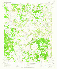
1961 Map of La Gotera
USGS Topo · Published 1963About this map
Nuestra Senora de la Luz de las Lagunitas and the massive Cebolleta Grant define the land tenure of this high-altitude landscape in the early 1960s. The survey reveals a region shaped by historical land grants and dispersed ranching operations, including the Evans Ranch and the former Rancho Agua Blanca (Site). Evidence of industry appears at the Dorey Mine, located along the winding course of the Cañon del Piojo. The drainage network is dominated by the Salado Creek and its many tributaries, while peaks such as Cerro de Jacobo and Cerro Chato rise above the valley floors. In the southwest corner, San Antonio Valley holds the small settlement of Dos Tristes, providing a glimpse into the localized water and ranching hubs that sustained life in the high desert of the Sandoval and Valencia County borderlands.
Find a feature on this map
34 named features on this map. Tap any name to fly to it.
Don’t see what you’re looking for? This feature index may not catch every label — zoom into the map to look around manually.
Map Details
Editions of this 1961 La Gotera Map
2 editions found
Other maps of this area

1883 · Mt. Taylor
USGS Topo · 1:250,000

1886 · Mt. Taylor
USGS Topo · 1:250,000

1892 · Mt. Taylor
USGS Topo · 1:250,000

1899 · Mt. Taylor
USGS Topo · 1:250,000

1954 · Herrera
USGS Topo · 1:24,000

1957 · Moquino
USGS Topo · 1:24,000
1957 · Arch Mesa
USGS Topo · 1:24,000

1958 · Albuquerque
USGS Topo · 1:250,000

1961 · Marquez
USGS Topo · 1:24,000

1961 · Cerro Tinaja
USGS Topo · 1:24,000