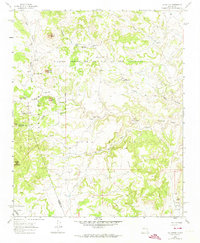
1961 Map of La Gotera
USGS Topo · Published 1974About this map
Nuestra Señora de la Luz de las Lagunitas land grant dominates the high country of the Sandoval and Valencia county line during the early 1960s. The landscape is defined by traditional New Mexican land tenure and resource use, with the West Boundary Agua Salada Grant and Cebolleta Grant Boundary meeting in the western canyons. This era shows a transition in land use, featuring active cattle operations like Evans Ranch alongside remnant locations such as the Rancho Agua Blanca (Site).
Find a feature on this map
53 named features on this map. Tap any name to fly to it.
Don’t see what you’re looking for? This feature index may not catch every label — zoom into the map to look around manually.
Map Details
Editions of this 1961 La Gotera Map
2 editions found
Other maps of this area

1883 · Mt. Taylor
USGS Topo · 1:250,000

1886 · Mt. Taylor
USGS Topo · 1:250,000

1892 · Mt. Taylor
USGS Topo · 1:250,000

1899 · Mt. Taylor
USGS Topo · 1:250,000

1954 · Herrera
USGS Topo · 1:24,000

1957 · Moquino
USGS Topo · 1:24,000
1957 · Arch Mesa
USGS Topo · 1:24,000

1958 · Albuquerque
USGS Topo · 1:250,000

1961 · Marquez
USGS Topo · 1:24,000

1961 · Cerro Tinaja
USGS Topo · 1:24,000