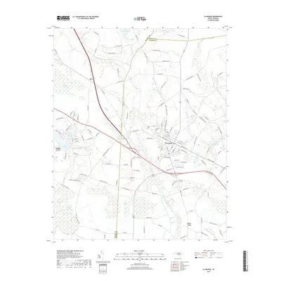
2019 Map of La Grange
USGS Topo · Published 2019About this map
La Grange serves as the central hub of this eastern North Carolina landscape, where the Norfolk Southern railroad line cuts directly through the heart of the community. The town's grid of streets is surrounded by a network of rural settlements and named crossroads, including Best to the northwest and Jenny Lind to the southeast. The geography is defined by a transition from organized farmland to low-lying wetlands and pocosin environments, such as Walnut Pocosin and Bogue Marsh. Local history is deeply embedded in the rural landscape through numerous named houses of worship like Saint John Church and Garris Chapel, alongside the Fairview Cem and Palmer Cem. Notable water features like Walters Millpond and Lake Wackena reflect the drainage patterns of Bear Cr and Little Marsh River as they wind through the coastal plain.
Find a feature on this map
129 named features on this map. Tap any name to fly to it.
Don’t see what you’re looking for? This feature index may not catch every label — zoom into the map to look around manually.
Map Details
Editions of this 2019 La Grange Map
This is the sole edition of this map. No revisions or reprints were ever made.
Other maps of this area

1914 · Kinston
USGS Topo · 1:48,000

1916 · Kinston
USGS Topo · 1:62,500

1953 · Rocky Mount
USGS Topo · 1:250,000

1954 · Rocky Mount
USGS Topo · 1:250,000

1957 · Goldsboro
USGS Topo · 1:62,500

1957 · Seven Springs
USGS Topo · 1:62,500

1958 · Deep Run
USGS Topo · 1:62,500

1980 · Seven Springs
USGS Topo · 1:24,000
1980 · Deep Run
USGS Topo · 1:24,000
1980 · Williams
USGS Topo · 1:24,000