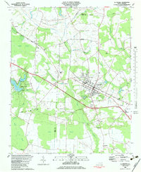
1983 Map of La Grange
USGS Topo · Published 1983About this map
La Grange serves as the focal point of this coastal plain landscape, where the Atlantic And East Carolina railroad bisects the town and dictates the local transport pattern. This 1980s-era geography reveals a transition between established agricultural centers and the surrounding wetlands, notably the Walnut Pocosin and Jones Pocosin. Rural life is anchored by numerous small community hubs and churches, such as Jackson Chapel, Rouse Chapel, and White Oak Grove Ch, which are scattered among family-named sites like Mays Store. The area's hydrology is defined by a network of drainage including Bear Creek, Moseley Creek, and Groundnut Creek, while localized features like Humphrey Sand Hill and Lake Wackena highlight the varied topography of the Wayne Co and Lenoir Co borderlands. The map also documents educational and industrial infrastructure of the time, from Frink Jr High Sch to several sewage disposal sites.
Find a feature on this map
53 named features on this map. Tap any name to fly to it.
Don’t see what you’re looking for? This feature index may not catch every label — zoom into the map to look around manually.
Map Details
Editions of this 1983 La Grange Map
This is the sole edition of this map. No revisions or reprints were ever made.
Other maps of this area

1914 · Kinston
USGS Topo · 1:48,000

1916 · Kinston
USGS Topo · 1:62,500

1953 · Rocky Mount
USGS Topo · 1:250,000

1954 · Rocky Mount
USGS Topo · 1:250,000

1957 · Goldsboro
USGS Topo · 1:62,500

1957 · Seven Springs
USGS Topo · 1:62,500

1958 · Deep Run
USGS Topo · 1:62,500

1980 · Seven Springs
USGS Topo · 1:24,000
1980 · Deep Run
USGS Topo · 1:24,000
1980 · Williams
USGS Topo · 1:24,000