1974 Map of La Habra
USGS Topo · Published 1977About this map
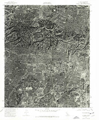
La Habra and the northern edge of Fullerton are captured in this orthophotoquad, which utilizes 1974 aerial photography to show the intense suburban densification of Orange County. Unlike traditional topographic maps, this imagery reveals the actual rooflines, parking lots, and residential street grids as they appeared during a period of significant growth. The terrain is a sharp study in land use, where the flat southern plains of the Los Angeles Basin meet the rising hills to the north. These northern slopes remain largely undeveloped or transitioning, showing the clear boundary between the established urban sprawl of La Habra and the natural topography that would soon face further development pressure.
Find a feature on this map
2 named features on this map. Tap any name to fly to it.
Don’t see what you’re looking for? This feature index may not catch every label — zoom into the map to look around manually.
Map Details
Editions of this 1974 La Habra Map
This is the sole edition of this map. No revisions or reprints were ever made.
Other maps of this area

1894 · Los Angeles
USGS Topo · 1:62,500

1894 · Pomona
USGS Topo · 1:62,500

1896 · Pasadena
USGS Topo · 1:62,500

1896 · Anaheim
USGS Topo · 1:62,500

1896 · Downey
USGS Topo · 1:62,500

1897 · Pomona
USGS Topo · 1:62,500

1898 · Pomona
USGS Topo · 1:62,500

1898 · Anaheim
USGS Topo · 1:62,500

1899 · Downey
USGS Topo · 1:62,500

1900 · Pasadena
USGS Topo · 1:62,500