
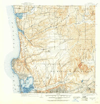
1930 Map of La Jolla
USGS Topo · Published 1955About this map
Camp Kearney sits at the center of this coastal landscape, marking a period of significant military and infrastructure development between the two World Wars. The coastal edge is defined by early twentieth-century growth in La Jolla, Pacific Beach, and Delmar, connected by the Surf Line and the Santa Fe railroad. The map reveals the early footprint of San Diego's northern expansion, from the established streets of Old Town and North San Diego to isolated settlements like Miramar and Merton.
Find a feature on this map
66 named features on this map. Tap any name to fly to it.
Don’t see what you’re looking for? This feature index may not catch every label — zoom into the map to look around manually.
Map Details
Editions of this 1930 La Jolla Map
2 editions found
Other maps of this area

1893 · El Cajon
USGS Topo · 1:62,500

1893 · Oceanside
USGS Topo · 1:62,500

1893 · Escondido
USGS Topo · 1:62,500

1898 · Oceanside
USGS Topo · 1:62,500

1901 · Elcajon
USGS Topo · 1:62,500

1901 · Escondido
USGS Topo · 1:62,500

1901 · Oceanside
USGS Topo · 1:62,500

1901 · San Luis Rey
USGS Topo · 1:125,000

1903 · Cuyamaca
USGS Topo · 1:125,000

1903 · La Jolla
USGS Topo · 1:62,500