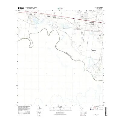
2016 Map of La Joya
USGS Topo · Published 2016About this map
The Rio Grande snakes through the southern reaches of this borderlands landscape, defining the international boundary between United States of America and Mexico. The northern half of the sheet reveals a dense network of residential colonias and established communities concentrated along the Military Rd and Highway 83 corridor. Established settlements like La Joya, Perezville, and Penitas are surrounded by numerous named residential developments including Colonia Camargo, Colonia Martinez, and Tierra Maria Colonia. Local history is anchored by the San Antonio Cem and San Jose Cem, while the industrial and utility infrastructure is represented by the Edinburg Settling Basin and Moore Airpark. The presence of Walker Lake and Penitas Lake near the river indicates the characteristic oxbow hydrology of the valley, supporting a mix of residential expansion and agricultural proximity.
Find a feature on this map
83 named features on this map. Tap any name to fly to it.
Don’t see what you’re looking for? This feature index may not catch every label — zoom into the map to look around manually.
Map Details
Editions of this 2016 La Joya Map
This is the sole edition of this map. No revisions or reprints were ever made.
Other maps of this area

1940 · Monte Christo
USGS Topo · 1:62,500

1949 · Mc Allen
USGS Topo · 1:250,000

1954 · McAllen
USGS Topo · 1:250,000

1956 · Garcias
USGS Topo · 1:62,500

1956 · Los Ebanos
USGS Topo · 1:62,500

1957 · Mc Allen
USGS Topo · 1:250,000

1962 · McAllen
USGS Topo · 1:250,000

1963 · La Joya
USGS Topo · 1:24,000

1963 · Citrus City
USGS Topo · 1:24,000
1963 · Alton
USGS Topo · 1:24,000