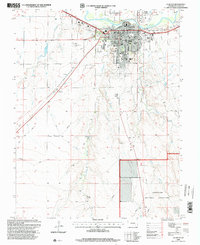
1996 Map of La Junta
USGS Topo · Published 2000About this map
The Arkansas River corridor serves as the anchor for this mid-1990s survey of La Junta, where the city's grid is defined by a dense concentration of civic institutions and neighborhoods. Educational history is particularly well-represented through numerous neighborhood facilities like Lincoln Sch, Park Sch, and the Otero Jr College campus. The rail-oriented layout of the town is shaped by the Atchison Topeka and Santa Fe line, which cuts through the northern edge near Fairview Cem and the Gaging Sta. Beyond the city limits, the landscape transitions into the open expanse of the Comanche National Grassland to the south. Distinctive landmarks of the era include the Drive-in Theater in the northeast and the Santa Fe National Historic Trail crossing the western plains through Ormega, marking the convergence of pioneer heritage with modern infrastructure.
Find a feature on this map
43 named features on this map. Tap any name to fly to it.
Don’t see what you’re looking for? This feature index may not catch every label — zoom into the map to look around manually.
Map Details
Editions of this 1996 La Junta Map
This is the sole edition of this map. No revisions or reprints were ever made.
Other maps of this area

1891 · Catlin
USGS Topo · 1:125,000

1891 · Higbee
USGS Topo · 1:125,000

1891 · Las Animas
USGS Topo · 1:125,000

1891 · Timpas
USGS Topo · 1:125,000

1893 · Higbee
USGS Topo · 1:125,000

1893 · Las Animas
USGS Topo · 1:125,000

1893 · Catlin
USGS Topo · 1:125,000

1894 · Timpas
USGS Topo · 1:125,000

1953 · Cheraw
USGS Topo · 1:24,000

1953 · Hadley
USGS Topo · 1:24,000