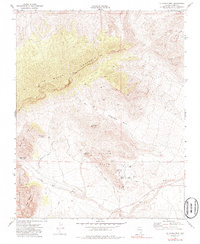
1972 Map of La Madre Mtn
USGS Topo · Published 1986About this map
La Madre Mountain dominates this portion of the Clark County desert, where the transition from high ridgelines to alluvial basins is marked by complex geology and early human utility. In the early 1970s, the landscape featured a network of water sources vital for both wildlife and early travelers, including White Rock Spring, Ash Creek Spring, and Red Spring. The presence of a Sandstone Quarry near the Calico Hills indicates the area's value for building materials, while a Prospect further north hints at smaller-scale mineral exploration.
Find a feature on this map
23 named features on this map. Tap any name to fly to it.
Don’t see what you’re looking for? This feature index may not catch every label — zoom into the map to look around manually.
Map Details
Editions of this 1972 La Madre Mtn Map
4 editions found
Other maps of this area

1907 · Las Vegas
USGS Topo · 1:250,000

1908 · Las Vegas
USGS Topo · 1:250,000

1952 · Corn Creek Springs
USGS Topo · 1:62,500

1952 · Blue Diamond
USGS Topo · 1:62,500

1954 · Las Vegas
USGS Topo · 1:250,000

1957 · Las Vegas
USGS Topo · 1:250,000

1957 · Charleston Peak
USGS Topo · 1:62,500

1957 · Mountain Springs
USGS Topo · 1:62,500

1959 · Las Vegas
USGS Topo · 1:250,000

1962 · Las Vegas
USGS Topo · 1:250,000