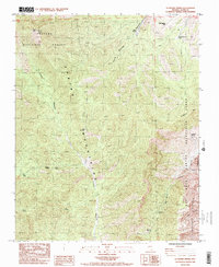
1984 Map of La Madre Spring
USGS Topo · Published 1984About this map
The Spring Mountains dominate this 1984 survey, revealing a landscape defined by dramatic elevation changes and essential water sources in the high desert of Clark County. This provisional edition documents the interface between the Toiyabe National Forest and the Red Rock Canyon Recreation Lands, highlighting a network of springs critical to the region's ecology and history. From Harris Springs in the north to Roses Spring and Switchback Spring further south, these water points dictated the movement of people and wildlife through the steep terrain.
Find a feature on this map
30 named features on this map. Tap any name to fly to it.
Don’t see what you’re looking for? This feature index may not catch every label — zoom into the map to look around manually.
Map Details
Editions of this 1984 La Madre Spring Map
2 editions found
Other maps of this area

1907 · Las Vegas
USGS Topo · 1:250,000

1908 · Las Vegas
USGS Topo · 1:250,000

1952 · Corn Creek Springs
USGS Topo · 1:62,500

1952 · Blue Diamond
USGS Topo · 1:62,500

1954 · Las Vegas
USGS Topo · 1:250,000

1957 · Las Vegas
USGS Topo · 1:250,000

1957 · Charleston Peak
USGS Topo · 1:62,500

1957 · Mountain Springs
USGS Topo · 1:62,500

1959 · Las Vegas
USGS Topo · 1:250,000

1962 · Las Vegas
USGS Topo · 1:250,000