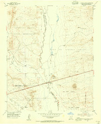
1954 Map of La Mesita Negra
USGS Topo · Published 1955About this map
The winding course of the Rio Puerco serves as a central artery through this high-desert landscape, defining the boundaries between several significant land grants and tribal territories. This mid-century survey captures a complex intersection of land tenure, where the Canoncito Navajo Indian Reservation and Laguna Indian Reservation meet the expansive Town of Atrisco Grant.
Find a feature on this map
21 named features on this map. Tap any name to fly to it.
Don’t see what you’re looking for? This feature index may not catch every label — zoom into the map to look around manually.
Map Details
Editions of this 1954 La Mesita Negra Map
4 editions found
Other maps of this area

1883 · Mt. Taylor
USGS Topo · 1:250,000

1886 · Mt. Taylor
USGS Topo · 1:250,000

1888 · Bernalillo
USGS Topo · 1:125,000

1889 · Albuquerque
USGS Topo · 1:125,000

1892 · Mt. Taylor
USGS Topo · 1:250,000

1893 · Albuquerque
USGS Topo · 1:125,000

1899 · Mt. Taylor
USGS Topo · 1:250,000

1917 · Cerro Verde
USGS Topo · 1:125,000

1952 · Wind Mesa
USGS Topo · 1:24,000

1952 · Dalies NW
USGS Topo · 1:24,000