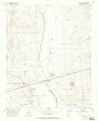
1954 Map of La Mesita Negra
USGS Topo · Published 1965About this map
Rio Puerco carves a central path through this mid-century New Mexico landscape, serving as a defining boundary for several historic land grants and reservations. The Rio Puerco Trading Post marks a key stop along the arterial highway, situated near the prominent volcanic landform of La Mesita Negra. This 1954 field survey illustrates a complex convergence of territorial boundaries, where the Cañoncito Navajo Indian Reservation meets the Town of Atrisco Grant and the Laguna Indian Reservation. To the south, the Pajarito Grant extends across the high desert terrain. The map records a network of established jeep trails and seasonal drainages like Cañada del Ojo and Cañada de los Apaches, providing a detailed look at the rural infrastructure and land management patterns of Bernalillo County before modern expansion.
Find a feature on this map
20 named features on this map. Tap any name to fly to it.
Don’t see what you’re looking for? This feature index may not catch every label — zoom into the map to look around manually.
Map Details
Editions of this 1954 La Mesita Negra Map
4 editions found
Other maps of this area

1883 · Mt. Taylor
USGS Topo · 1:250,000

1886 · Mt. Taylor
USGS Topo · 1:250,000

1888 · Bernalillo
USGS Topo · 1:125,000

1889 · Albuquerque
USGS Topo · 1:125,000

1892 · Mt. Taylor
USGS Topo · 1:250,000

1893 · Albuquerque
USGS Topo · 1:125,000

1899 · Mt. Taylor
USGS Topo · 1:250,000

1917 · Cerro Verde
USGS Topo · 1:125,000

1952 · Wind Mesa
USGS Topo · 1:24,000

1952 · Dalies NW
USGS Topo · 1:24,000