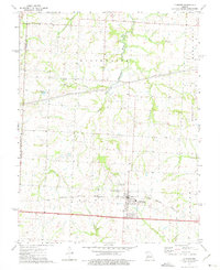
1973 Map of La Monte
USGS Topo · Published 1975About this map
The town of La Monte serves as the primary hub on this early 1970s survey, situated along the Missouri Pacific railroad line. The landscape reflects a transition between prairie agricultural land and the wooded riparian corridors of the Blackwater River, which meanders across the northern half of the sheet. Rural social centers are sparse but significant, including the County Line Ch and the small settlement of Stokley located near the headwaters of Elk Creek. This period captures the region's established infrastructure, from the local La Monte Cem to the industrial presence of multiple pipelines cutting across the central plains. The drainage patterns of Beaverdam Creek and Brushy Creek illustrate the natural topography that shaped early land parcels and township boundaries in this portion of Pettis and Johnson Counties.
Find a feature on this map
21 named features on this map. Tap any name to fly to it.
Don’t see what you’re looking for? This feature index may not catch every label — zoom into the map to look around manually.
Map Details
Editions of this 1973 La Monte Map
This is the sole edition of this map. No revisions or reprints were ever made.
Other maps of this area

1885 · Warrensburg
USGS Topo · 1:125,000

1887 · Sedalia
USGS Topo · 1:125,000

1887 · Warrensburg
USGS Topo · 1:125,000

1894 · Sedalia
USGS Topo · 1:125,000

1894 · Warrensburg
USGS Topo · 1:125,000

1917 · Knobnoster
USGS Topo · 1:62,500

1939 · Sweet Springs
USGS Topo · 1:62,500

1940 · Sweet Springs
USGS Topo · 1:62,500

1941 · Sweet Springs
USGS Topo · 1:62,500

1944 · Sedalia West
USGS Topo · 1:24,000