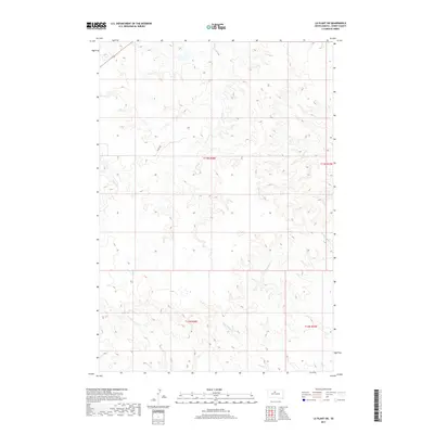
2017 Map of La Plant SW
USGS Topo · Published 2017About this map
Virgin Cr meanders through this portion of Dewey County, carving a drainage pattern that defines the high plains topography of the Missouri River plateau. This 2017 study illustrates a vast, open landscape primarily shaped by intermittent waterways like Stove Cr and Porters Cr, which flow through the northern reaches of the quadrangle. The sparse human footprint is marked by the presence of Co Rd 15G, providing a primary artery through the rolling terrain. In the southern sections, the headwaters of E Br Willow Cr and W Br Willow Cr converge, while No Heart Cr cuts across the southwestern corner, showing the essential relationship between drainage and land use in this semi-arid region. These features reflect the enduring character of South Dakota's rural interior, where the land remains largely governed by the natural flow of seasonal creeks and established section lines.
Find a feature on this map
12 named features on this map. Tap any name to fly to it.
Don’t see what you’re looking for? This feature index may not catch every label — zoom into the map to look around manually.
Map Details
Editions of this 2017 La Plant SW Map
This is the sole edition of this map. No revisions or reprints were ever made.
Other maps of this area

1951 · Virginia
USGS Topo · 1:24,000

1951 · Ridgeview NE
USGS Topo · 1:24,000

1951 · La Plant
USGS Topo · 1:24,000

1953 · McIntosh
USGS Topo · 1:250,000

1954 · Pierre
USGS Topo · 1:250,000

1958 · Pierre
USGS Topo · 1:250,000

1958 · McIntosh
USGS Topo · 1:250,000

1981 · Charlie Creek
USGS Topo · 1:24,000
1981 · No Heart Creek NE
USGS Topo · 1:24,000
1981 · Stove Creek
USGS Topo · 1:24,000