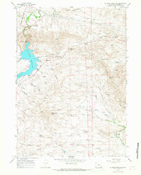
1964 Map of La Prele Reservoir
USGS Topo · Published 1968About this map
La Prele Reservoir dominates the western landscape of this mid-century survey, its blue waters held by a dam with a spillway elevation of 5490 feet. The surrounding Converse County terrain is a complex network of ranch roads and water management features, including the Main Canal and West Side Ditch branching off La Prele Creek. Historical travel routes are clearly marked, most notably the path of the Emigrant Trail cutting across the northern reaches near Table Mountain.
Find a feature on this map
53 named features on this map. Tap any name to fly to it.
Don’t see what you’re looking for? This feature index may not catch every label — zoom into the map to look around manually.
Map Details
Editions of this 1964 La Prele Reservoir Map
This is the sole edition of this map. No revisions or reprints were ever made.
Other maps of this area

1949 · Orpha
USGS Topo · 1:24,000

1949 · Careyhurst
USGS Topo · 1:24,000

1949 · Poison Lake
USGS Topo · 1:24,000

1949 · Douglas
USGS Topo · 1:24,000

1949 · Chalk Buttes
USGS Topo · 1:24,000

1950 · Careyhurst
USGS Topo · 1:24,000

1950 · Poison Lake
USGS Topo · 1:24,000

1950 · Douglas
USGS Topo · 1:24,000

1950 · Orpha
USGS Topo · 1:24,000
1950 · Chalk Buttes
USGS Topo · 1:24,000