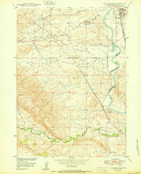
1950 Map of Chalk Buttes
USGS Topo · Published 1950About this map
The North Platte River carves through the eastern edge of this landscape, anchoring the development of Douglas just as it transitions into the expansive high plains. The era is defined by the coexistence of pioneering legacy and modern industrial growth, evidenced by the Oregon Trail Monument standing near active pipe lines and a complex rail network. Two major lines, the Chicago and Northwestern and the Chicago Burlington and Quincy, parallel the river corridor, supporting the regional economy. Beyond the town and its Municipal Airport, the terrain rises toward the prominent Sheep Mountain and the distinctive formations of the Chalk Buttes. Water management is central to this environment, with numerous unnamed ditches and named drainages like Wagon Hound Creek and Little Tick Bed Creek feeding into the Platte, alongside localized features like Hot Springs and the Warm Springs Hill.
Find a feature on this map
22 named features on this map. Tap any name to fly to it.
Don’t see what you’re looking for? This feature index may not catch every label — zoom into the map to look around manually.
Map Details
Editions of this 1950 Chalk Buttes Map
This is the sole edition of this map. No revisions or reprints were ever made.
Other maps of this area

1949 · Orpha
USGS Topo · 1:24,000

1949 · Irvine
USGS Topo · 1:24,000

1949 · Poison Lake
USGS Topo · 1:24,000

1949 · Douglas
USGS Topo · 1:24,000

1949 · Dilts Ranch
USGS Topo · 1:24,000

1949 · Chalk Buttes
USGS Topo · 1:24,000

1949 · Antelope Creek
USGS Topo · 1:24,000

1950 · Poison Lake
USGS Topo · 1:24,000

1950 · Douglas
USGS Topo · 1:24,000

1950 · Orpha
USGS Topo · 1:24,000