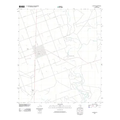
2010 Map of La Pryor
USGS Topo · Published 2010About this map
La Pryor serves as the central hub of this South Texas landscape, defined by a grid of local roads and its proximity to the winding course of the Nueces River. The river system and its various tributaries, including Sand Ridge Creek and Mustang Creek, dictate the movement and settlement patterns of this Zavala County quadrangle. A notable human impact on the hydrology is evident at the Knowles Reservoir Dam, which sits just east of the main town site.
Find a feature on this map
22 named features on this map. Tap any name to fly to it.
Don’t see what you’re looking for? This feature index may not catch every label — zoom into the map to look around manually.
Map Details
Editions of this 2010 La Pryor Map
This is the sole edition of this map. No revisions or reprints were ever made.
Other maps of this area

1898 · Uvalde
USGS Topo · 1:125,000

1899 · Uvalde
USGS Topo · 1:125,000

1939 · La Pryor
USGS Topo · 1:62,500

1953 · Crystal City
USGS Topo · 1:250,000

1954 · San Antonio
USGS Topo · 1:250,000

1955 · Crystal City
USGS Topo · 1:250,000

1957 · San Antonio
USGS Topo · 1:250,000

1957 · Batesville
USGS Topo · 1:62,500

1960 · Pulliam Ranch
USGS Topo · 1:24,000
1960 · Sand Mountain
USGS Topo · 1:24,000