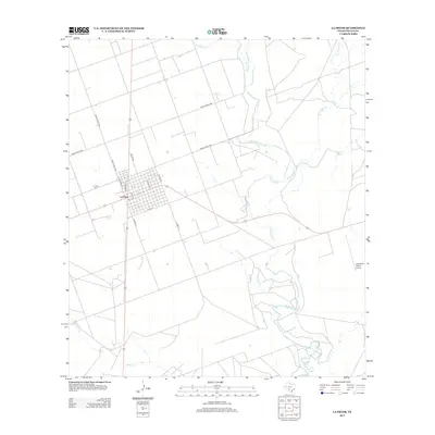
2013 Map of La Pryor
USGS Topo · Published 2013About this map
La Pryor serves as the primary hub of this Zavala County landscape, where the street grid is clearly defined by historical thoroughfares like Pryor Ave and Railroad St. Just west of the town center lies the La Pryor Cem, a key site for genealogical research in the region. The map reveals a transition from the structured residential blocks of the settlement to the broad, sweeping drainage systems of the Nueces River and Mustang Cr to the east. The presence of the Westwind Ranch Airport toward the southeastern corner highlights the continued importance of regional aviation in this rural Texas setting. The landscape is interconnected by a network of ranch roads, such as Ranch Road 1436, which trace the path toward significant water features like Sand Ridge Cr.
Find a feature on this map
19 named features on this map. Tap any name to fly to it.
Don’t see what you’re looking for? This feature index may not catch every label — zoom into the map to look around manually.
Map Details
Editions of this 2013 La Pryor Map
This is the sole edition of this map. No revisions or reprints were ever made.
Other maps of this area

1898 · Uvalde
USGS Topo · 1:125,000

1899 · Uvalde
USGS Topo · 1:125,000

1939 · La Pryor
USGS Topo · 1:62,500

1953 · Crystal City
USGS Topo · 1:250,000

1954 · San Antonio
USGS Topo · 1:250,000

1955 · Crystal City
USGS Topo · 1:250,000

1957 · San Antonio
USGS Topo · 1:250,000

1957 · Batesville
USGS Topo · 1:62,500

1960 · Pulliam Ranch
USGS Topo · 1:24,000
1960 · Sand Mountain
USGS Topo · 1:24,000