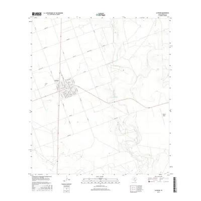
2016 Map of La Pryor
USGS Topo · Published 2016About this map
La Pryor serves as the primary hub of this South Texas landscape, where the town’s grid is clearly defined by residential streets such as E Edith St and S Grant Ave. To the west, the La Pryor Cem provides a point of historical interest for genealogical research. The surrounding terrain is dominated by a complex hydrological network, most notably the meandering course of the Nueces River and several of its tributaries, including Mustang Cr and Sand Ridge Cr. Human impact on the water table is evident through features like Knowles Reservoir and Fence Tank. Modern transportation and commerce are represented by the Westwind Ranch Airport to the southeast, while the intersection of several farm-to-market roads and local routes like Kausen Rd and Ranch Rd 1986 reveal the area’s ranching and agricultural orientation.
Find a feature on this map
51 named features on this map. Tap any name to fly to it.
Don’t see what you’re looking for? This feature index may not catch every label — zoom into the map to look around manually.
Map Details
Editions of this 2016 La Pryor Map
This is the sole edition of this map. No revisions or reprints were ever made.
Other maps of this area

1898 · Uvalde
USGS Topo · 1:125,000

1899 · Uvalde
USGS Topo · 1:125,000

1939 · La Pryor
USGS Topo · 1:62,500

1953 · Crystal City
USGS Topo · 1:250,000

1954 · San Antonio
USGS Topo · 1:250,000

1955 · Crystal City
USGS Topo · 1:250,000

1957 · San Antonio
USGS Topo · 1:250,000

1957 · Batesville
USGS Topo · 1:62,500

1960 · Pulliam Ranch
USGS Topo · 1:24,000
1960 · Sand Mountain
USGS Topo · 1:24,000