
1938 Map of Labadieville
USGS Topo · Published 1938About this map
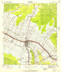
Sugar cane cultivation and rail transportation dominate this 1938 landscape along the banks of Bayou Lafourche. The region is defined by a dense concentration of agricultural estates such as Cedar Grove Plantation, St Rose Plantation, and White Plantation, which line the fertile bayou corridor. The settlement of Labadieville serves as a central hub, supported by the competing tracks of the Southern Pacific and Texas and Pacific railroads. Inland from the bayou, the terrain transitions into complex drainage networks like the Himalaya Canal and Phillips Canal. Smaller communities and rural landmarks, including New Belmont Ch and Brule Guillot Sch, illustrate the social fabric of Assumption Parish during this era. The map also reveals specialized infrastructure like the Narrow Gage lines used to transport crops from the fields to processing centers.
Find a feature on this map
40 named features on this map. Tap any name to fly to it.
Don’t see what you’re looking for? This feature index may not catch every label — zoom into the map to look around manually.
Map Details
Editions of this 1938 Labadieville Map
This is the sole edition of this map. No revisions or reprints were ever made.
Other maps of this area

1892 · Gibson
USGS Topo · 1:62,500

1892 · Thibodaux
USGS Topo · 1:62,500

1897 · Gibson
USGS Topo · 1:62,500

1927 · Thibodaux NW
USGS Topo · 1:31,680

1932 · Thibodaux NE
USGS Topo · 1:31,680

1932 · Thibodaux SE
USGS Topo · 1:31,680

1932 · Thibodaux SW
USGS Topo · 1:31,680

1935 · Morgan City
USGS Topo · 1:62,500
1938 · Lafourche
USGS Topo · 1:24,000

1939 · Gibson
USGS Topo · 1:62,500