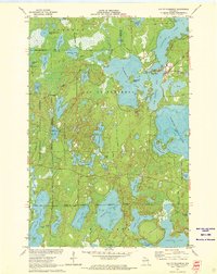
1971 Map of Lac Du Flambeau
USGS Topo · Published 1973About this map
Lac du Flambeau serves as the focal point of this Northwoods landscape, where the Lac du Flambeau Indian Reservation Boundary meets the Chequamegon National Forest. The map detail reveals a complex aquatic geography defined by large bodies like Crawling Stone Lake and Long Interlaken Lake, alongside smaller, uniquely named waters such as Broken Bow Lake and Tippecanoe Lake. Human activity and administration are noted through the Indian Agency, a Cem, and a local campground. Significant lake features like Strawberry Island and Moss Lake are documented with depth curves provided by the Wisconsin Department of Natural Resources. The transport network of the early 1970s is represented by routes like Indian Village Road and Old Prairie Road, tracing the ways people moved through these woods and wetlands before modern development shifted the local footprint.
Find a feature on this map
55 named features on this map. Tap any name to fly to it.
Don’t see what you’re looking for? This feature index may not catch every label — zoom into the map to look around manually.
Map Details
Editions of this 1971 Lac Du Flambeau Map
3 editions found
Other maps of this area

1938 · Lac Du Flambeau
USGS Topo · 1:48,000

1939 · Lac Du Flambeau
USGS Topo · 1:48,000

1939 · Winchester
USGS Topo · 1:48,000

1940 · Mercer
USGS Topo · 1:48,000

1941 · Pike Lake
USGS Topo · 1:48,000

1942 · Pike Lake
USGS Topo · 1:48,000

1945 · Mercer
USGS Topo · 1:48,000

1946 · Winchester
USGS Topo · 1:48,000

1946 · Lac Du Flambeau
USGS Topo · 1:48,000

1947 · Mercer
USGS Topo · 1:48,000