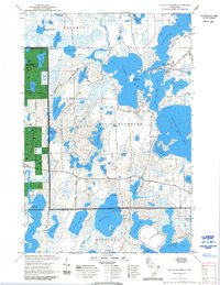
1971 Map of Lac Du Flambeau
USGS Topo · Published 1992About this map
Lac du Flambeau Indian Reservation encompasses a vast complex of glacial kettle lakes and wetlands, centered on the settlement of Lac du Flambeau. The 1971 field check reveals a landscape defined by water and forest management, including the Park Falls District Ranger station and State Land within the Chequamegon National Forest. The map detail shows the intricate shorelines of Flambeau Lake and Crawling Stone Lake, along with cultural landmarks like Strawberry Island and the Wabasso Lake Campground and Picnic Area.
Find a feature on this map
61 named features on this map. Tap any name to fly to it.
Don’t see what you’re looking for? This feature index may not catch every label — zoom into the map to look around manually.
Map Details
Editions of this 1971 Lac Du Flambeau Map
3 editions found
Other maps of this area

1938 · Lac Du Flambeau
USGS Topo · 1:48,000

1939 · Lac Du Flambeau
USGS Topo · 1:48,000

1939 · Winchester
USGS Topo · 1:48,000

1940 · Mercer
USGS Topo · 1:48,000

1941 · Pike Lake
USGS Topo · 1:48,000

1942 · Pike Lake
USGS Topo · 1:48,000

1945 · Mercer
USGS Topo · 1:48,000

1946 · Winchester
USGS Topo · 1:48,000

1946 · Lac Du Flambeau
USGS Topo · 1:48,000

1947 · Mercer
USGS Topo · 1:48,000