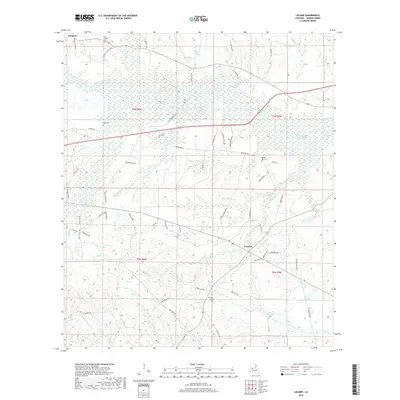
2018 Map of Lacamp
USGS Topo · Published 2018About this map
The Calcasieu River winds through this Vernon Parish landscape, defining a region where small communities like Simpson and Lacamp are connected by a web of parish roads and family-named loops. The mapping reflects a rural topography heavily dissected by numerous watercourses, including Schoolhouse Cr, Spring Br, and the N Fork Mill Cr. Local history and genealogy are anchored by several dispersed burial grounds such as Pine Island Cem, Oak Grove Cem, and Mayo Cem, which often serve as the primary landmarks for these unincorporated areas. The network of roads, including Hicks School Rd and Bennett Collins Loop, suggests a pattern of homesteads and small-scale timber or agricultural land use typical of the Louisiana piney woods. These detailed labels provide a clear view of the territorial divisions and water systems before further modern development.
Find a feature on this map
80 named features on this map. Tap any name to fly to it.
Don’t see what you’re looking for? This feature index may not catch every label — zoom into the map to look around manually.
Map Details
Editions of this 2018 Lacamp Map
This is the sole edition of this map. No revisions or reprints were ever made.
Other maps of this area

1937 · Chopin SW
USGS Topo · 1:31,680

1937 · Chopin SE
USGS Topo · 1:31,680

1941 · Slagle
USGS Topo · 1:62,500

1942 · Kisatchie
USGS Topo · 1:62,500

1943 · Leander
USGS Topo · 1:62,500

1943 · Kisatchie
USGS Topo · 1:62,500

1944 · Chopin
USGS Topo · 1:62,500

1944 · Slagle
USGS Topo · 1:62,500

1948 · Chopin
USGS Topo · 1:62,500

1953 · Alexandria
USGS Topo · 1:250,000