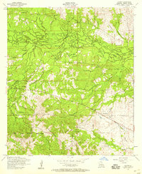
1954 Map of Lacamp
USGS Topo · Published 1959About this map
The settlement of Hicks sits at a rural crossroads in Vernon Parish, surrounded by a dense network of timber-country infrastructure. During the mid-1950s, this portion of the Fort Polk Military Reservation was crisscrossed by several miles of a dismantled railroad, marking the legacy of the region's former logging industry. The landscape is defined by the winding course of the Calcasieu River and its numerous tributaries, including Mill Creek, Dry Creek, and Mims Creek. Local family and community history is preserved through scattered sites such as Mayo Cemetery, Scott Cemetery, and Pine Island Cemetery, along with several country congregations like Flactor Church, Oak Grove Church, and Lacamp Church. The transition from active rail use to a more forested, military-adjacent landscape is evident in the numerous sections of abandoned line trailing through the central and southern portions of the map.
Find a feature on this map
1 named feature on this map. Tap any name to fly to it.
Don’t see what you’re looking for? This feature index may not catch every label — zoom into the map to look around manually.
Map Details
Editions of this 1954 Lacamp Map
This is the sole edition of this map. No revisions or reprints were ever made.
Other maps of this area

1937 · Chopin SW
USGS Topo · 1:31,680

1937 · Chopin SE
USGS Topo · 1:31,680

1941 · Slagle
USGS Topo · 1:62,500

1942 · Kisatchie
USGS Topo · 1:62,500

1943 · Leander
USGS Topo · 1:62,500

1943 · Kisatchie
USGS Topo · 1:62,500

1944 · Chopin
USGS Topo · 1:62,500

1944 · Slagle
USGS Topo · 1:62,500

1948 · Chopin
USGS Topo · 1:62,500

1953 · Alexandria
USGS Topo · 1:250,000