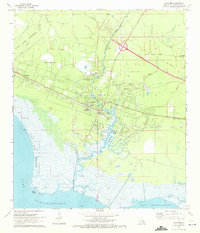
1971 Map of Lacombe
USGS Topo · Published 1972About this map
Lacombe Bayou and the smaller Cypress Bayou wind through this coastal St. Tammany Parish landscape as it appeared in the early 1970s. The settlement of Lacombe serves as a central hub, flanked by institutional landmarks such as the Carmel Convent, Holy Redeemer College, and Lourdes Ch. Along the northern shores of Lake Pontchartrain, the State Game Preserve protects the marshy wetlands near Goose Point, where a Seaplane Base is marked along the waterfront. Transportation and industry are evidenced by the Gulf Mobile and Ohio railroad corridor and local resources like the Fish Hatchery. Of particular interest to genealogists and local historians are smaller community markers, including the Lafere Cem and the Chahta-Ima High Sch, which provide a detailed look at the social infrastructure of the bayou country during this era of transitioning infrastructure.
Find a feature on this map
25 named features on this map. Tap any name to fly to it.
Don’t see what you’re looking for? This feature index may not catch every label — zoom into the map to look around manually.
Map Details
Editions of this 1971 Lacombe Map
3 editions found
Other maps of this area

1891 · Spanish Fort
USGS Topo · 1:62,500

1892 · Chef Menteur
USGS Topo · 1:62,500

1935 · Slidell
USGS Topo · 1:62,500

1935 · Covington
USGS Topo · 1:62,500

1936 · North Shore
USGS Topo · 1:31,680

1936 · South Point
USGS Topo · 1:31,680

1936 · Chef Menteur
USGS Topo · 1:62,500

1936 · Spanish Fort
USGS Topo · 1:62,500

1939 · Slidell
USGS Topo · 1:62,500

1939 · Covington
USGS Topo · 1:62,500