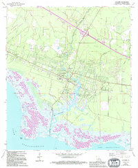
1971 Map of Lacombe
USGS Topo · Published 1994About this map
Lacombe Bayou and Bayou Lacombe wind through the North Shore lowlands of Lake Pontchartrain in this 1971 survey. The landscape is defined by the transition from the St Tammany State Game Refuge marshes at Goose Point to the settled piney woods of Lacombe and Big Branch. This edition reflects a community deeply rooted in its local institutions, evidenced by the concentration of religious and educational sites such as Holy Redeemer College, Carmel Convent, and Lourdes Ch. Genealogists will find significant value in the documentation of several family-named burial grounds, including Cousin Cem, Williams Cem, and Lafere Cem. A Seaplane Base on the bayou and the Dixie Ranch Lookout Tower to the northeast highlight the region's specialized infrastructure for coastal and forest management.
Find a feature on this map
30 named features on this map. Tap any name to fly to it.
Don’t see what you’re looking for? This feature index may not catch every label — zoom into the map to look around manually.
Map Details
Editions of this 1971 Lacombe Map
3 editions found
Other maps of this area

1891 · Spanish Fort
USGS Topo · 1:62,500

1892 · Chef Menteur
USGS Topo · 1:62,500

1935 · Slidell
USGS Topo · 1:62,500

1935 · Covington
USGS Topo · 1:62,500

1936 · North Shore
USGS Topo · 1:31,680

1936 · South Point
USGS Topo · 1:31,680

1936 · Chef Menteur
USGS Topo · 1:62,500

1936 · Spanish Fort
USGS Topo · 1:62,500

1939 · Slidell
USGS Topo · 1:62,500

1939 · Covington
USGS Topo · 1:62,500