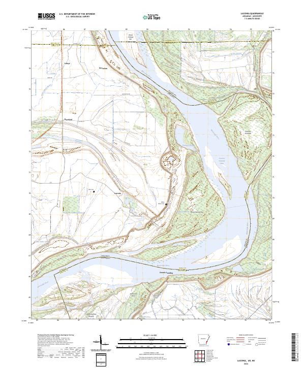
2024 Map of Laconia
USGS Topo · Published 2024About this map
The Mississippi River forms a complex boundary between Arkansas and Mississippi in this riverine landscape, where the shifting channel has created geographic curiosities like Island Number 69 and Island Number Seventy. On the Arkansas side, the settlement of Laconia is situated behind the massive levee system, a landscape defined by its proximity to the water and the engineering required to manage it. The presence of features like the Laconia Crevasse and Knowlton Crevasse indicates the historical power of floodwaters in this region, which have shaped the agricultural bottoms and drainage patterns of Deep Bayou and Little Cypress Bayou. Genealogists and local historians can locate small family or community landmarks such as Luke Cem and White Parker Cem near the riverbanks. The Delta Heritage Trl follows an old corridor through Deerfield, providing a modern connection to these agricultural hamlets like Lorays and Knowlton that have long relied on the alluvial soils of the delta.
Find a feature on this map
50 named features on this map. Tap any name to fly to it.
Don’t see what you’re looking for? This feature index may not catch every label — zoom into the map to look around manually.
Map Details
Editions of this 2024 Laconia Map
This is the sole edition of this map. No revisions or reprints were ever made.
Other maps of this area

1930 · Mellwood
USGS Topo · 1:62,500

1939 · Henrico
USGS Topo · 1:62,500

1939 · Pace
USGS Topo · 1:62,500

1939 · Big Island
USGS Topo · 1:62,500

1939 · Mellwood
USGS Topo · 1:62,500

1948 · Helena
USGS Topo · 1:250,000

1950 · Helena
USGS Topo · 1:250,000

1953 · Greenwood
USGS Topo · 1:250,000

1954 · Mellwood
USGS Topo · 1:62,500

1954 · Henrico
USGS Topo · 1:62,500