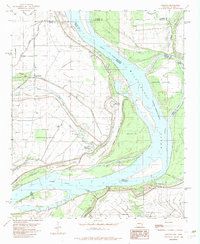
1982 Map of Laconia
USGS Topo · Published 1982About this map
Mississippi River hydraulics dominate this landscape on the border of Arkansas and Mississippi, where the river's shifting course is traced by the Cessions Towhead Chute and the Chute of Island No 69. The map records a complex network of backwaters and bayous, including Deep Bayou, Swan Lake, and Parker Bayou, illustrating the alluvial character of the Delta. Inland, the Laconia Circle represents a distinct agricultural or land-management footprint near the settlement of Laconia.
Find a feature on this map
33 named features on this map. Tap any name to fly to it.
Don’t see what you’re looking for? This feature index may not catch every label — zoom into the map to look around manually.
Map Details
Editions of this 1982 Laconia Map
This is the sole edition of this map. No revisions or reprints were ever made.
Other maps of this area

1930 · Mellwood
USGS Topo · 1:62,500

1939 · Henrico
USGS Topo · 1:62,500

1939 · Pace
USGS Topo · 1:62,500

1939 · Big Island
USGS Topo · 1:62,500

1939 · Mellwood
USGS Topo · 1:62,500

1948 · Helena
USGS Topo · 1:250,000

1950 · Helena
USGS Topo · 1:250,000

1953 · Greenwood
USGS Topo · 1:250,000

1954 · Mellwood
USGS Topo · 1:62,500

1954 · Henrico
USGS Topo · 1:62,500