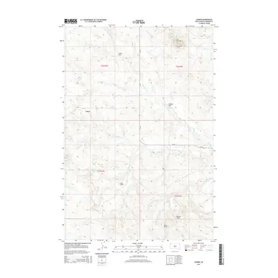
2015 Map of Ladner
USGS Topo · Published 2015About this map
Ladner sits as the central point of this West River landscape in Harding County, where the high plains are defined by dramatic rises and complex drainage systems. To the north, the elevation culminates at Mt McKinley, while the southern landscape is marked by the distinctive profiles of White Butte and Pointed Butte. The area is characterized by an intricate network of intermittent waterways, including North Bull Creek, Middle Cr, and Cottonwood Creek, which have carved out topographical features like Gallager Draw and Cooper Draw. This 2015 survey shows a remote ranching environment where life revolves around isolated settlements like Mud Butte and vital water sources such as Finlander Spring and Reed Spring. The layout of local roads like CR-733 and CR-797 provides a glimpse into the modern infrastructure of this rural South Dakota territory.
Find a feature on this map
24 named features on this map. Tap any name to fly to it.
Don’t see what you’re looking for? This feature index may not catch every label — zoom into the map to look around manually.
Map Details
Editions of this 2015 Ladner Map
This is the sole edition of this map. No revisions or reprints were ever made.
Other maps of this area

1935 · Buffalo
USGS Topo · 1:125,000

1954 · Lemmon
USGS Topo · 1:250,000

1957 · Lemmon
USGS Topo · 1:250,000

1969 · Ladner NE
USGS Topo · 1:24,000

1969 · Table Mountain
USGS Topo · 1:24,000

1969 · Ladner
USGS Topo · 1:24,000

1969 · Ladner SE
USGS Topo · 1:24,000
1971 · Lahti Butte
USGS Topo · 1:24,000

1971 · McKenzie Butte
USGS Topo · 1:24,000

1973 · Gallup Creek
USGS Topo · 1:24,000