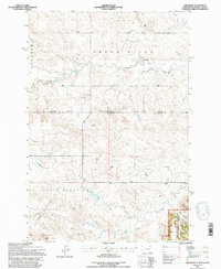
1993 Map of Ladner NE
USGS Topo · Published 1996About this map
The N Fork Grand River cuts through this high plains borderland, where the Standard Parallel separates North and South Dakota. The landscape is defined by massive topographic features like Table Mountain and the Cave Hills, the latter of which contains the North Nursery within the Custer National Forest. Human presence is sparse but precisely marked by isolated rural outposts such as the Janvrin Ranch and the Grand River Sch, reflecting a ranching economy dependent on reliable water sources like Lone Tree Creek and Crooked Creek.
Find a feature on this map
24 named features on this map. Tap any name to fly to it.
Don’t see what you’re looking for? This feature index may not catch every label — zoom into the map to look around manually.
Map Details
Editions of this 1993 Ladner NE Map
This is the sole edition of this map. No revisions or reprints were ever made.
Other maps of this area

1935 · Reva
USGS Topo · 1:125,000

1935 · Buffalo
USGS Topo · 1:125,000

1953 · Dickinson
USGS Topo · 1:250,000

1954 · Lemmon
USGS Topo · 1:250,000

1957 · Dickinson
USGS Topo · 1:250,000

1957 · Lemmon
USGS Topo · 1:250,000

1968 · Bowman SW
USGS Topo · 1:24,000

1968 · Eagles Nest Butte
USGS Topo · 1:24,000

1968 · Ludlow
USGS Topo · 1:24,000

1969 · Ladner NE
USGS Topo · 1:24,000