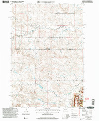
2005 Map of Ladner NE
USGS Topo · Published 2007About this map
Table Mountain and the Bullock Hills dominate the topography of this high plains region straddling the border between South Dakota and North Dakota. This 2005 revision reflects a landscape where remote ranching and public land management define the community structure. The map captures the course of the Grand River as it flows through the northern section, while smaller drainages like Trunk Creek and Staadt Creek carve paths through the southern terrain. Evidence of rural community life is visible through landmarks such as the Grand River Sch and the Cox Ch near the eastern margin. Large portions of the eastern edge are designated as part of the Custer National Forest, specifically encompassing the Cave Hills area. Man-made features include a Scoria Pit and the established Janvrin Ranch, showing the continued economic reliance on grazing and local geological resources in Harding and Bowman Counties.
Find a feature on this map
20 named features on this map. Tap any name to fly to it.
Don’t see what you’re looking for? This feature index may not catch every label — zoom into the map to look around manually.
Map Details
Editions of this 2005 Ladner NE Map
This is the sole edition of this map. No revisions or reprints were ever made.
Other maps of this area

1935 · Reva
USGS Topo · 1:125,000

1935 · Buffalo
USGS Topo · 1:125,000

1953 · Dickinson
USGS Topo · 1:250,000

1954 · Lemmon
USGS Topo · 1:250,000

1957 · Dickinson
USGS Topo · 1:250,000

1957 · Lemmon
USGS Topo · 1:250,000

1968 · Bowman SW
USGS Topo · 1:24,000

1968 · Eagles Nest Butte
USGS Topo · 1:24,000

1968 · Ludlow
USGS Topo · 1:24,000

1969 · Ladner NE
USGS Topo · 1:24,000