
1943 Map of Ladson
USGS Topo · Published 1943About this map
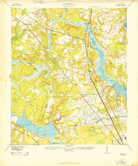
Magnolia Gardens and the estate at Runnymede flank the Ashley River in this 1943 survey, which documents the rural and early industrial landscapes of the South Carolina Lowcountry. The map captures a critical period of infrastructure development, featuring the Charleston Military Airport and the sprawling Charleston Waterworks on Goose Creek. Three major rail lines—the Southern, Atlantic Coast Line, and Seaboard—bisect the territory, anchoring settlements like Ladson and Tenmile. Local heritage is preserved through markers such as Goose Creek Ch and Ashley Ch, alongside historic names like Otranto and Windsor Hill. This transition era shows the area as it was before suburban expansion, defined by riverine plantations and the strategic intersection of railroads and wartime aviation.
Find a feature on this map
37 named features on this map. Tap any name to fly to it.
Don’t see what you’re looking for? This feature index may not catch every label — zoom into the map to look around manually.
Map Details
Editions of this 1943 Ladson Map
2 editions found
Other maps of this area

1919 · Ladson
USGS Topo · 1:21,120

1919 · Johns Island
USGS Topo · 1:21,120

1919 · Summerville
USGS Topo · 1:48,000

1919 · Cordesville
USGS Topo · 1:48,000

1919 · Melgrove
USGS Topo · 1:21,120

1919 · Charleston
USGS Topo · 1:21,120

1920 · Ravenels
USGS Topo · 1:62,500

1920 · Summerville
USGS Topo · 1:62,500

1940 · Melgrove
USGS Topo · 1:24,000

1944 · Ravenels
USGS Topo · 1:62,500