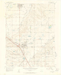
1956 Map of Lafayette
USGS Topo · Published 1958About this map
Lafayette and the developing area of Broomfield Heights anchor this mid-century portrait of a changing landscape where agricultural irrigation meets industrial transition. An extensive network of water management features, including the Community Ditch, Highline Ditch, and Goodhue Ditch, feeds numerous reservoirs such as Lafayette Reservoir and Brunner Reservoir, illustrating the critical role of water rights in the region's development.
Find a feature on this map
46 named features on this map. Tap any name to fly to it.
Don’t see what you’re looking for? This feature index may not catch every label — zoom into the map to look around manually.
Map Details
Editions of this 1956 Lafayette Map
This is the sole edition of this map. No revisions or reprints were ever made.
Other maps of this area

1890 · East Denver
USGS Topo · 1:125,000

1899 · West Denver
USGS Topo · 1:125,000

1902 · Greeley
USGS Topo · 1:125,000

1904 · Niwot
USGS Topo · 1:62,500

1938 · Derby
USGS Topo · 1:24,000

1939 · Golden
USGS Topo · 1:24,000

1940 · Eastlake
USGS Topo · 1:31,680

1940 · Lafayette
USGS Topo · 1:31,680

1940 · Derby
USGS Topo · 1:31,680

1941 · Arvada
USGS Topo · 1:31,680