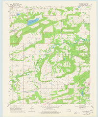
1968 Map of Lafayette
USGS Topo · Published 1977About this map
Sans Bois Creek meanders through this portion of Haskell County, defining a landscape shaped by both natural drainage and mid-century industrial development. The small settlement of Lafayette serves as a central point, surrounded by evidence of the region's energy and mineral history, including numerous Gas Wells, a Strip Mine, and the Choctaw Mine. To the east, Seven Devils Mountain rises above the creek valley, while the northern edge is marked by the expansion of the Robert S Kerr Reservoir and several smaller bodies of water like Lake John Wells and Lone Star Steel Lake. Local genealogy and community life are grounded in landmarks such as Lafayette Ch, Siloam Spring Ch, and Old Panther Cem. The presence of an (Old) RR Grade and an Air Shaft further underscores the area's transition from early mining and rail transport to the water management projects of the 1960s.
Find a feature on this map
33 named features on this map. Tap any name to fly to it.
Don’t see what you’re looking for? This feature index may not catch every label — zoom into the map to look around manually.
Map Details
Editions of this 1968 Lafayette Map
2 editions found
Other maps of this area

1900 · Sansbois
USGS Topo · 1:125,000

1900 · Sallisaw
USGS Topo · 1:125,000

1909 · Sans Bois
USGS Topo · 1:125,000

1911 · Sallisaw
USGS Topo · 1:125,000

1911 · Sansbois
USGS Topo · 1:125,000

1946 · Fort Smith
USGS Topo · 1:250,000

1962 · Stigler East
USGS Topo · 1:24,000

1962 · Stigler West
USGS Topo · 1:24,000

1965 · Fort Smith
USGS Topo · 1:250,000

1967 · Fort Smith
USGS Topo · 1:250,000