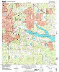
1999 Map of Lafayette
USGS Topo · Published 2003About this map
The eastern edges of Tallahassee meet a complex landscape of wetlands and institutional lands in this late 20th-century survey. The sprawling Lake Lafayette system dominates the central terrain, including Piney Z Lake and Alford Arm, providing a focal point for conservation efforts like the L Kirk Edwards State Wildlife and Environment Area. The map reveals the civic footprint of the era through the Federal Correctional Institution, Prison Farm, and schools such as Lincoln High Sch. Local genealogy is well-supported by numerous rural landmarks, including St Peter Cemetery, Sodafield Cem, and a collection of community churches such as Mt Pisgah Ch and New Zion Ch. Traditional transit routes like the St Augustine Road and the Miccosukee Canopy Road Greenway indicate how the capital city expanded while preserving significant green spaces like Tom Brown Park and the J R Alford Greenway.
Find a feature on this map
46 named features on this map. Tap any name to fly to it.
Don’t see what you’re looking for? This feature index may not catch every label — zoom into the map to look around manually.
Map Details
Editions of this 1999 Lafayette Map
This is the sole edition of this map. No revisions or reprints were ever made.
Other maps of this area

1940 · Tallahassee
USGS Topo · 1:62,500

1942 · Tallahassee
USGS Topo · 1:62,500

1943 · Tallahassee
USGS Topo · 1:62,500

1954 · Lloyd
USGS Topo · 1:24,000

1954 · Lafayette
USGS Topo · 1:24,000

1954 · Cody
USGS Topo · 1:24,000

1954 · Woodville
USGS Topo · 1:24,000

1954 · Tallahassee
USGS Topo · 1:250,000

1959 · Tallahassee
USGS Topo · 1:250,000

1960 · Tallahassee
USGS Topo · 1:250,000