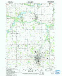
1993 Map of Lagrange
USGS Topo · Published 1993About this map
The county seat of Lagrange anchors this northern Indiana survey, showing the town's expansion with residential developments like Woodland Hills and Northwood situated near the local hospital and fairgrounds. Further north, the historic village of Howe is home to the Howe Military Academy, set within a landscape defined by the winding Fawn River and Pigeon River. The era's educational infrastructure is well-represented by several rural institutions, including Lima-Brighton Sch and Indian Trail Sch.
Find a feature on this map
53 named features on this map. Tap any name to fly to it.
Don’t see what you’re looking for? This feature index may not catch every label — zoom into the map to look around manually.
Map Details
Editions of this 1993 Lagrange Map
This is the sole edition of this map. No revisions or reprints were ever made.
Other maps of this area

1914 · Three Rivers
USGS Topo · 1:62,500

1916 · Three Rivers
USGS Topo · 1:62,500

1943 · Three Rivers
USGS Topo · 1:62,500

1947 · Mongo
USGS Topo · 1:24,000

1947 · Lagrange
USGS Topo · 1:24,000

1947 · Wolcottville
USGS Topo · 1:24,000

1947 · Oliver Lake
USGS Topo · 1:24,000

1953 · Fort Wayne
USGS Topo · 1:250,000

1956 · Fort Wayne
USGS Topo · 1:250,000

1959 · Wolcottville
USGS Topo · 1:24,000