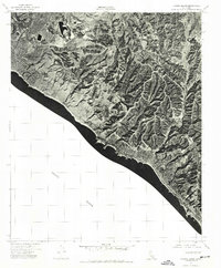
1974 Map of Laguna Beach
USGS Topo · Published 1977About this map
San Joaquin Hills dominate the coastal topography of this orthophotoquad, showcasing the dramatic transition from rugged upland ridges to the shoreline. The mid-1970s landscape reveals the early stages of suburban expansion along the coast, particularly in Newport Beach where residential developments are clearly visible against the native terrain. Southward along the Pacific Ocean, the settlement of Laguna Beach is tightly clustered against the base of the hills, illustrating how the geography constrained and shaped the community's growth. The aerial photography highlights the intricate network of canyons and ridges that define this stretch of the Orange County coast before the denser development of later decades arrived.
Find a feature on this map
4 named features on this map. Tap any name to fly to it.
Don’t see what you’re looking for? This feature index may not catch every label — zoom into the map to look around manually.
Map Details
Editions of this 1974 Laguna Beach Map
This is the sole edition of this map. No revisions or reprints were ever made.
Other maps of this area

1896 · Santa Ana
USGS Topo · 1:62,500

1901 · Southern California Sheet No. 1
USGS Topo · 1:250,000

1901 · Santa Ana
USGS Topo · 1:62,500

1902 · Capistrano
USGS Topo · 1:125,000

1902 · Corona
USGS Topo · 1:125,000

1904 · Southern California Sheet No. 2
USGS Topo · 1:250,000

1904 · Southern California Sheet No. 1
USGS Topo · 1:250,000

1906 · Capistrano
USGS Topo · 1:125,000

1932 · Newport Beach
USGS Topo · 1:31,680

1932 · Tustin
USGS Topo · 1:31,680