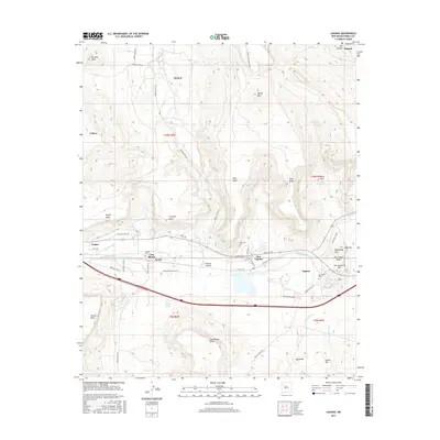
2017 Map of Laguna
USGS Topo · Published 2017About this map
Laguna and the surrounding Pueblo of Laguna villages are mapped here at the foot of diverse high-desert mesas. The central corridor is defined by the Rio San Jose, which supports agricultural infrastructure like the Paraje Irrigation Ditch and the Casa Blanca Ditch. These water systems connect the settlements of Paraje, Casa Blanca, and New Laguna, tracing a historical path of habitation in a landscape marked by prominent volcanic and sandstone formations. To the north, the terrain rises toward Wheat Mtn and Frog Mesa, while to the south, Casa Blanca Mesa and Bug Mesa overlook the Rio San Jose valley. The map reveals a high density of named landmarks such as Two Feathers Hill and The Indian Peaks, alongside cultural sites like the San Jose Cem and Eckerman Cem, which serve as vital markers for genealogical research in this region.
Find a feature on this map
60 named features on this map. Tap any name to fly to it.
Don’t see what you’re looking for? This feature index may not catch every label — zoom into the map to look around manually.
Map Details
Editions of this 2017 Laguna Map
This is the sole edition of this map. No revisions or reprints were ever made.
Other maps of this area

1883 · Mt. Taylor
USGS Topo · 1:250,000

1886 · Mt. Taylor
USGS Topo · 1:250,000

1892 · Mt. Taylor
USGS Topo · 1:250,000

1899 · Mt. Taylor
USGS Topo · 1:250,000

1917 · Cerro Verde
USGS Topo · 1:125,000

1917 · Broom Mountain
USGS Topo · 1:125,000

1954 · Socorro
USGS Topo · 1:250,000

1957 · Mount Taylor
USGS Topo · 1:24,000

1957 · Laguna
USGS Topo · 1:24,000

1957 · Moquino
USGS Topo · 1:24,000