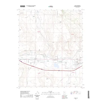
2023 Map of Laguna
USGS Topo · Published 2023About this map
Laguna and New Laguna serve as the primary hubs in this high-desert landscape, where the Rio San Jose and human-engineered waterways like the Paraje Irrigation Ditch define the settlement patterns. The map highlights a series of distinct communities including Paraje, Casa Blanca, Seama, and Encinal, many of which are situated near prominent geological landmarks such as Seama Mesa and Casa Blanca Mesa. The transportation network is a mix of modern infrastructure and historical pathways, featuring the Old Route 66 Rd alongside numerous tribal and service routes. The placement of San Jose Cem, Eckerman Cem, and Paraje Cem offers significant value for genealogical research, anchoring family histories to specific locations within the tribal lands. From the heights of Wheat Mountain to the depths of Encinal Canyon, the map illustrates a landscape where traditional water management and transit routes have shaped the community footprint.
Find a feature on this map
70 named features on this map. Tap any name to fly to it.
Don’t see what you’re looking for? This feature index may not catch every label — zoom into the map to look around manually.
Map Details
Editions of this 2023 Laguna Map
This is the sole edition of this map. No revisions or reprints were ever made.
Other maps of this area

1883 · Mt. Taylor
USGS Topo · 1:250,000

1886 · Mt. Taylor
USGS Topo · 1:250,000

1892 · Mt. Taylor
USGS Topo · 1:250,000

1899 · Mt. Taylor
USGS Topo · 1:250,000

1917 · Cerro Verde
USGS Topo · 1:125,000

1917 · Broom Mountain
USGS Topo · 1:125,000

1954 · Socorro
USGS Topo · 1:250,000

1957 · Mount Taylor
USGS Topo · 1:24,000

1957 · Laguna
USGS Topo · 1:24,000

1957 · Moquino
USGS Topo · 1:24,000