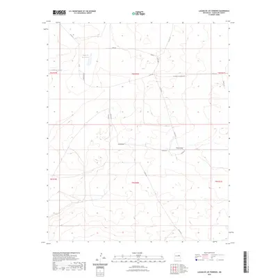
2023 Map of Laguna De Los Terreros
USGS Topo · Published 2023About this map
Laguna de los Terreros provides a focal point for this arid Guadalupe County landscape, where water management and ranch access roads define the human imprint on the terrain. The intermittent waters of the Cañada de Breñedo and Monias Draw underscore the ephemeral nature of the local hydrology, essential for livestock in this high-plains environment. Evidence of local engineering appears at the Borica Dam, a vital structure for capturing seasonal runoff in a region dominated by wide drainage patterns.
Find a feature on this map
23 named features on this map. Tap any name to fly to it.
Don’t see what you’re looking for? This feature index may not catch every label — zoom into the map to look around manually.
Map Details
Editions of this 2023 Laguna De Los Terreros Map
This is the sole edition of this map. No revisions or reprints were ever made.
Other maps of this area

1954 · Fort Sumner
USGS Topo · 1:250,000

1958 · Fort Sumner
USGS Topo · 1:250,000

1963 · Puerto Creek
USGS Topo · 1:24,000

1966 · Borica SW
USGS Topo · 1:24,000

1966 · Borica
USGS Topo · 1:24,000

1978 · El Morro Ranch SE
USGS Topo · 1:24,000

1978 · El Morro Ranch
USGS Topo · 1:24,000

1978 · Laguna De Los Terreros
USGS Topo · 1:24,000
1978 · Pastura
USGS Topo · 1:24,000

1978 · El Morro Ranch NW
USGS Topo · 1:24,000